The Railway Track
![]()
Maps may be downloaded from Ordnance Survey Get-a-map service. Alternatively, click here for a Google Map. You may also wish to see the local weather forecast. DISCLAIMER: LINKS TO OTHER INTERNET SITES ARE INCLUDED AS A CONVENIENCE TO USERS. ACCESS AND USE OF SUCH SITES, INCLUDING INFORMATION, MATERIAL, PRODUCTS AND SERVICES THEREIN, IS SOLELY AT YOUR OWN RISK.
|
||
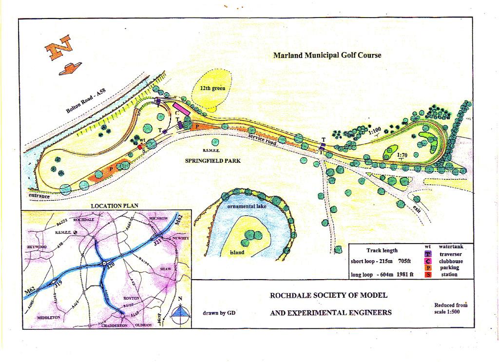
| Track Location | Springfield Park, Bolton Road (A58), Rochdale, OL11 4RE. For sat nav users - Latitude: 53.602864, Longitude: -2.188747 (taken from Google Maps) |
|
| Track | Elevated; Steel; 1980 feet (604m); 31/2, 5 and 71/4 inch gauges |
|
| Gradients | 1:100 UP and 1:70 DOWN (MAXIMUM) |
|
| Radius | 40 feet (MINIMUM) |
|
| Services | 12V and 24V DC power, air, water, coal, trucks |
|
| Facilities | Car parking, toilet, ornamental lake, children's play area, the largest park with open landscape and wooded slopes down to the Roch Valley |
|
| Public Running | Sunday afternoons from Easter to late October, rides 50p |
|
| Visitors Welcome | Live steam loco owners will need their current boiler certificate, together with club membership card. A spark arrestor or smoke deflector would also be required. Battery electric and petrol loco owners will also need their club membership card. For insurance purposes, when visiting, please make yourself known to a club member who will sign you in as a visitor. A copy of the Track Rules may be dowloaded (PDF format, approximately 40kb) by clicking here |
|
For further details, please contact us. |
||